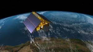
The satellite—roughly the size of a full-size pickup truck—lifted off aboard a SpaceX Falcon 9 rocket from Launch Complex 4 East at Vandenberg Space Force Base in California at 9:21 p.m. PST on November 16. Ground control made first contact with the spacecraft at 10:54 p.m. over Northern Canada, confirming that all systems were functioning normally.
Nicky Fox, associate administrator of NASA’s Science Mission Directorate, said the mission will play a vital role in safeguarding coastal and ocean-based activities. “Understanding tidal patterns down to the inch is critical in protecting how we use our oceans every day. Sentinel-6B will build upon the legacy of Sentinel-6 Michael Freilich by making sea level measurements that improve forecasts used by communities, businesses, and operations across the country,” she said. Fox added that the mission will also support safer ocean reentry for astronauts, including crews returning from future Artemis Moon missions.
Operating from low Earth orbit hundreds of miles above the planet, Sentinel-6B will gather precise global and regional sea level data, helping scientists monitor rising seas and shifting ocean patterns. The satellite will eventually replace Sentinel-6 Michael Freilich, launched in 2020, which serves as the world’s reference standard for sea level measurements used to calibrate other satellites.
The mission is a collaborative effort between NASA, the European Space Agency (ESA), the European Organisation for the Exploitation of Meteorological Satellites (EUMETSAT), and NOAA, and forms part of the EU’s Copernicus program. Simonetta Cheli of ESA said the launch underscores the importance of global cooperation. “This achievement showcases the power of international partnerships in addressing global challenges. Sentinel-6B will gather data on wind speeds, wave heights, temperature, and humidity, aiding marine weather forecasting and improving our understanding of ocean dynamics,” she said.
Sentinel-6B is the second in the Copernicus Sentinel-6/Jason-CS series, continuing a decades-long effort to monitor Earth’s oceans via radar altimetry dating back to the early 1990s. Like its predecessor, it will measure wind speeds, wave heights, sea surface temperature, and atmospheric humidity. By tracking sea surface height variations, the satellite can detect warmer ocean regions that fuel tropical storms and hurricanes, as well as reveal interactions between major currents—such as the Gulf Stream—and wave systems that create hazardous maritime conditions.
Karen St. Germain, director of NASA’s Earth Science Division, emphasized the satellite’s direct value to coastal communities and global industries. “Sentinel-6B will collect ocean surface observations that will inform decisions critical to coastal communities, commercial shipping and fishing, national defense, and emergency preparedness and response,” she said. “This is what NASA does—puts advanced technology and science into action for the benefit of the nation.”
Once fully in position, Sentinel-6B will fly approximately 30 seconds behind Sentinel-6 Michael Freilich to allow for cross-calibration of instruments. After this process is complete, the older satellite will shift to a different orbit, and Sentinel-6B will become the official global reference for sea level measurements, circling Earth about 13 times per day at an altitude of 830 miles (1,336 kilometers).
Dave Gallagher, director of NASA’s Jet Propulsion Laboratory, highlighted the mission’s advanced sensing capabilities, noting that Sentinel-6B can measure 90% of Earth’s oceans with accuracy down to fractions of an inch—adding crucial data for scientists, governments, and industries worldwide.


